Magnificent Maps in Euston
Whether you’re a complete map novice who can’t find their way around an A to Z, or an expert who can easily tell a Mercator from a Gall-Peters projection, there’ll be something for you at the British Library’s Magnificent Maps: Power, Propaganda and Art exhibition.
This collection shows off 200 of the best maps, atlases and globes from the Library’s impressive stash. With examples ranging from as far back as 200AD to pieces produced in 2008, this exhibition documents the craft of cartography through the ages (also it’s free!).
Much more than this, however, the purpose of the exhibition is to reveal how the significance of maps stretches far beyond their mere geographical use.
Almost immediately after walking through the door, visitors are informed that before the 18th century there was little distinction between maps and works of art – and leaving the gallery, I found it impossible to disagree. The exquisite intricacy and beautiful imagery contained within the maps themselves are awe-inspiring, and comfortably stand up as works of art in their own right. One of the greatest examples is a reproduction of the Venetian monk Fra Mauro’s wonderful world map made in 1450 documents Marco Polo’s exploration of the Orient. Its beautiful colours and amazing detail are a tribute to the glory of his voyage.
The real revelation of the exhibition though is that, as well as their artistic merits, these maps treat visitors to a unique insight into how people viewed the world in the past, which you can’t get in any history text book. The most revealing of these are the fascinating medieval world maps or mappa mundi, filled with biblical imagery they reveal how religion mixed with geography in the 13th century.
For history nerds (such as yours truly) this is as good as it gets, but the Library goes to great lengths to allow even the most history phobic to appreciate the symbolic and political importance of these maps. Impressive interactive displays highlight details you might otherwise miss, using magnified projections to point out the key aspects of the more prominent exhibits.
By grouping pieces together in terms of where they would be displayed, in public places, schoolroom or in a private study for example, the exhibition successfully highlights the subtle political uses of each map. However, this approach rather than one based on geography or time period can be confusing at times. One moment you’re looking at a 17th century map of Germany, turn around and there’s one of London from 2008, which can be quite disconcerting.
Furthermore some of the sections feel empty compared to others, particularly the section of maps in public places, despite containing some of the most fascinating examples of 20th century propaganda. Overall these slight deficiencies do not diminish the fact that these maps’ artistic beauty and deeper meanings makes this an experience not to be missed.
You’ll never look at a map the same again, don’t be surprised to find yourself looking for hidden messages in the tube map on the way home.
Magnificent Maps: Power, Propaganda and Art is showing until September 19 at:
The British Library
St Pancras
96 Euston Road
Euston
NW1 2DB
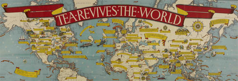
Image: MACDONALD GILL ‘Tea Revives the World’ (1940) courtesy of the British Library Board
You may also like


About Post Author
